My interests include exploring habitat associations
of en route migrating songbirds using remote sensing tools.
I am part of an effort granted by the United States Geologic
Survey that will examine seasonal nocturnal songbird
migration over the southwestern United States as detected
by Doppler weather surveillance radar. We will be looking
at archived data from fourteen NEXRAD stations beginning
with Brownsville, TX, extending in a swath to San Diego,
CA.
A NEXt generation weather surveillance
RADar emits a pulse of longwave electromagnetic radiation
that
intercepts a
target at a specific pulse volume (a 3-Dimensional position)
and a portion of the pulse is reflected back to the same
antenna, where it is received and interpreted. Properties
that differ between the outgoing pulse and return pulse
(at each pulse volume) contribute to 3 types of data: reflectivity,
the overall size/density of the target; radial velocity,
the target’s change in position relative to the radar;
and spectrum width, the similarity in movements of multiple
targets per pulse volume. These properties are evident
from migrating birds aloft. Considering the vast scale
of bird migration, these three types of data from the NEXRAD
archives will efficiently provide information on a migration
event
that would be extremely daunting if collected by other
means. By examining archived data in a Geographic Information
System, I will tackle these questions:
• How does migrant density vary
regionally across the southwest?
• What habitat preferences or associations do migrants exhibit
during stopover in the southwest, and how may these
patterns of habitat use be shaped by regional variations in migrant
density?
• To what extent does radar beam obstruction limit application
of radar for bird studies in mountainous terrain?
• How do migrant flight altitude distributions vary across
the southwest?
• How do migrant directions of travel vary across the southwest?
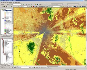
The above are images from ArcGIS software
showing the incorporation of Digital Elevation Models (left)
and archived NEXRAD data and land-use/land-cover data (right),
both of the Tucson, AZ area.
Department of Biological Sciences
The University of Southern
Mississippi
118 College Drive # 5018
Hattiesburg, MS
39406-0001
(601)266-4394
rodney.felix@usm.edu